I came across an intriguing claim on X that I wanted to validate. It ended up being a very quick endeavor (less than an hour) but seemed like something that might be of interest here. The claim is that many of the notable ancient sites on Earth are all found along a straight line around the planet, the Great Circle. The details I found were inconsistent and erroneous on the mapping details so I wrote a program to, given a list of ancient sites, calculate the optimal straight-line path around the globe such that it is a “best fit” to the data. This is reminiscent of a best fit plot in other statistical analysis so I calculated an R² value which is a measure of how well the trendline fits that data. Here are the sites I took into consideration:
| Ancient Site | Latitude | Longitude |
|---|---|---|
| Giza | 29.98° | 31.13° |
| Siwa | 29.203171° | 25.519545° |
| Tassili n’Ajjer | 25.1667° | 8.3333° |
| Paratoari | -12.6706° | -71.4567° |
| Ollantaytambo | -13.25806° | -72.26333° |
| Machu Picchu | -13.16° | -72.54° |
| Nazca | -14.69° | -75.13° |
| Easter Island | -27.11° | -109.35° |
| Aneityum Island | -20.192937° | 169.818238° |
| Preah Vihear | 14.39056° | 104.68028° |
| Sukhothai | 17.0167° | 99.7000° |
| Pyay | 18.85° | 95.22° |
| Khajuraho | 24.8500° | 79.9250° |
| Mohenjo Daro | 27.3292° | 68.1389° |
| Persepolis | 29.9350° | 52.8900° |
| Ur | 30.9575° | 46.1018° |
| Petra | 30.33° | 35.44° |
Running the code (which is on github here) it calculated the following:
Optimal new north pole coordinates:
Longitude: -138.646087°
Latitude: 59.682122°
Total distance to equator: 416.83 km
R^2 value: 0.9998
Distances from each site to the new equator:
Giza: 6.66 km
Siwa: 17.42 km
Tassili n’Ajjer: 101.85 km
Paratoari: 10.13 km
Ollantaytambo: 7.19 km
Machu Picchu: 16.32 km
Nazca: 7.35 km
Easter Island: 9.62 km
Aneityum Island: 20.88 km
Preah Vihear: 31.58 km
Sukhothai: 4.37 km
Pyay: 17.82 km
Khajuraho: 29.59 km
Mohenjo Daro: 25.62 km
Persepolis: 13.73 km
Ur: 80.59 km
Petra: 16.12 km
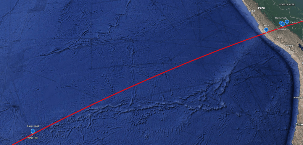
An R² of 0.9998 is a very high correlation and as you can see most of the sites I am using are in fact incredibly close to the line, so that is quite encouraging; But I want to see it on a map! So I wrote and ran another program to generate a KML (a GIS file to draw survey lines and markers on maps) that would draw the path and plot the points. This program takes the alternate “north” pole and calculates and translates the path to our normal Lat/Lon coordinate system. With the KML in hand I loaded it into Google Earth and it is quite clear to see the alignment, the alternate “North” pole and to explore along the line in remote areas looking for other lost ancient sites perhaps! Here it is as a public Google Earth map for you to explore as well (and the KML file is in my GIT repository to get the raw file if you want it).


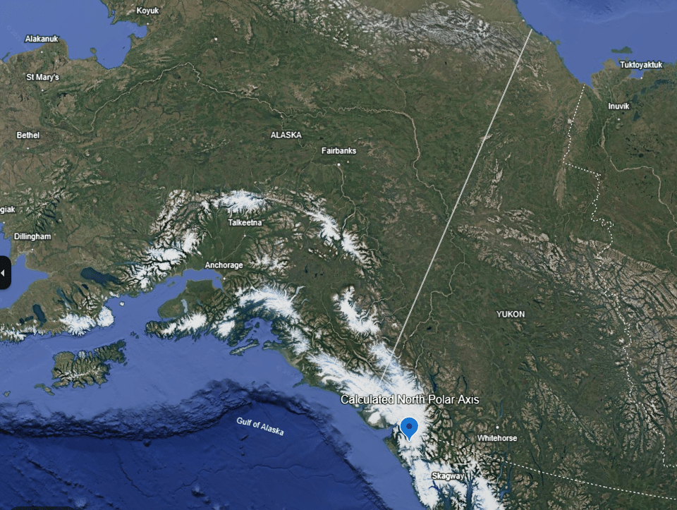
So what should we make of this? There is of course a selection bias, as we have excluded sites like Stone Henge, Göbekli Tepe, and all those in North and Central America. Given enough sites you might be able to derive arbitrary lines that fit them no matter what. That said, this is quite a long list that really do line up so well it is hard to easily dismiss! My intuition is to question if this path ever was the equator of the Earth. Precision, nutation and Polar motion wouldn’t account for this, so it could only be the consequence of a the landmasses shifting on the planet. This is theorized to potentially happen during polar reversals where the crust decouples from the mantle and the weight of the ice caps cause those masses to migrate towards the equator. So in that hypothesis, Alaska would have been located near north pole the mass of ice on the north and south pole, when considered with the rest of the land masses distributed on the planet would have shifted around 30°, or around 2000 miles. It would be fascinating to setup that math problem to see if that corresponds to what would have happened given those starting circumstance (perhaps I will…). I have seen similar projections for the next apocalyptic shift (thought by many to be targeting 2040 based on projections of the magnetic excursion that is rapidly accelerating!).